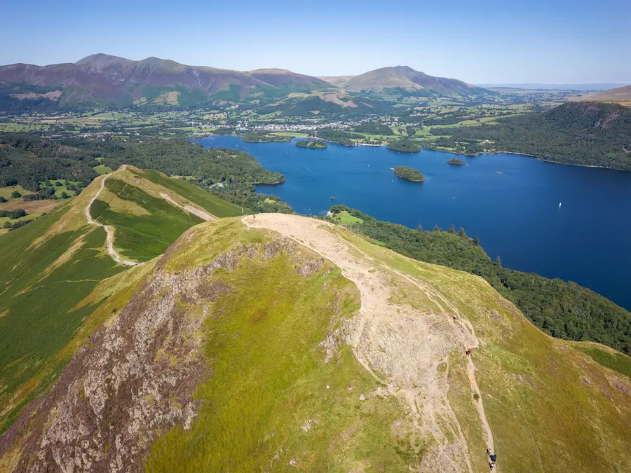
The Lake District covers 2,362 square kilometres of Cumbria, making it the largest national park in England. It was designated in 1951, among the first, and inscribed as a UNESCO World Heritage Site in 2017 — as a cultural landscape, notably, rather than a natural one, on the grounds that the fells, walls and farms are a thousand years of human work as much as geology.
Keswick sits in the northern Lakes, which is a distinct region within it and in several ways the better half.
The south — Windermere, Ambleside, Bowness — takes the great majority of the visitors. The north takes fewer, and what it has instead is bigger, barer country.
Skiddaw (931 m) rises directly behind Keswick, the fourth-highest mountain in England and one of the oldest rocks in the district — Skiddaw slate, smooth-sloped and grassy, quite unlike the crags to the south.
Blencathra (868 m), east of the town, is the finest-looking fell in the Lakes from the road, with its five ridges and the notorious knife-edge of Sharp Edge.
Derwentwater, below the town, is the shallowest and arguably the loveliest of the lakes, with its wooded islands and its ring of fells.
Borrowdale runs south from it into the highest ground in England — Scafell Pike (978 m), Scafell, Great Gable — and is the wettest inhabited valley in the country, which is why it is so green.
Bassenthwaite Lake, north of Keswick, is the only body of water in the district actually called a “lake”; the rest are meres and waters.
It is not a wilderness and not publicly owned. It is a lived-in working landscape of hill farms, forestry, quarries and villages, with about 40,000 residents, and the National Park Authority regulates development rather than owning the land. The National Trust is the largest single landowner, holding around a quarter of it.
The drystone walls, the hefted Herdwick flocks, the bracken and the sheep-cropped grass are all products of that farming, and the open fell tops exist because of a thousand years of grazing.
Buses are unusually good for a rural area. From Keswick: the 555 to Ambleside and Windermere, the 77/77A Honister Rambler round Buttermere and Whinlatter, the 78 into Borrowdale, the X4/X5 west to Cockermouth and Penrith. The Borrowdale and Honister services in particular open up walks with no car.
Trains do not reach Keswick — the line closed in 1972 — but Penrith on the West Coast Main Line is 30 minutes by bus, and Windermere has a branch line.
Parking in the honeypots is charged, limited and full by mid-morning in season. Buses are genuinely the better plan.
Rain. Borrowdale receives over 3,000 mm a year and Seathwaite is the wettest inhabited place in England. Waterproofs are not optional.
The fells are mountains. Weather changes fast, cloud comes down, and mountain rescue teams here are among the busiest in Britain. Take a map, a compass and warm layers, and check the Mountain Weather Information Service forecast rather than the town one.
Free. There is no entry charge to the national park.
2,362 square kilometres — the largest national park in England.
It was inscribed in 2017 as a cultural landscape: the fells, walls and farming are recognised as a thousand years of human work.
Scafell Pike at 978 metres, the highest in England, reached from Borrowdale among other valleys.
Yes from Keswick — the bus network into Borrowdale, Buttermere and over to Windermere is good, and driving in season means fighting for parking.
Borrowdale, south of Keswick, gets over 3,000 mm of rain a year and is the wettest inhabited valley in England.